NEED TO KNOW
-
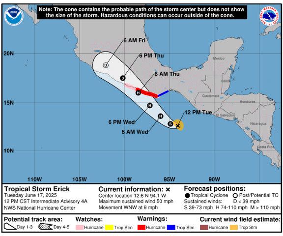
Tropical Storm Erick has formed in the eastern Pacific, and forecasters expect the storm to develop into a hurricane by the end of Tuesday, June 17
-
Erick is the fourth named storm of the season in the eastern Pacific
-
The storm could possibly reach “major” hurricane status as it approaches Mexico later this week
Tropical Storm Erick has formed in the eastern Pacific and is expected to “rapidly” develop into a hurricane.
Advertisement
Advertisement
The system reached tropical storm strength on Tuesday, June 17, and currently has maximum sustained winds of 45 mph, according to a public advisory published at 9 a.m. local time by the National Hurricane Center (NHC) in Miami.
Erick “is expected to rapidly intensify” over the next “day or two,” and forecasters predict the storm will reach hurricane strength by late Tuesday or early on Wednesday, June 18.
Additionally, Erick is forecast to be near or at major hurricane strength — described by the NHC as Category 3 status or higher — “when it approaches the coast of southern Mexico” on Wednesday night and Thursday, June 19, according to the NHC.
Government officials in Mexico have issued a Hurricane Warning from Puerto Angel to Punta Maldonado, while a Hurricane Watch has been issued west of Punta Maldonado to Acapulco.
Advertisement
Advertisement
A Tropical Storm Warning has been issued east of Puerto Angel to Salina Cruz, as well.
NHS/NOAA
Tropical Storm Erick’s Coastal Watches/Warnings and Forecast Cone
Erick is currently moving toward the west-northwest at near 9 mph, and is expected to move even slower to the northwest later on Tuesday, according to the NHC.
Heavy rainfall, life threatening floods, mudslides and “dangerous” storm surge are expected to accompany the storm. The weather agency has stated the storm “could produce rainfall totals of 8 to 16 inches, with maximum totals of 20 inches, across the Mexican states of Oaxaca and Guerrero.”
A Category 3 hurricane on the Saffir-Simpson scale is defined as having sustained wind speeds of 111 to 129 mph, according to the NHC.
Advertisement
Advertisement
These storms can cause “devastating damage” to impacted communities, including snapped or uprooted trees, “major” damage to roofing and decking, as well as power outages that can last “for several days to weeks after the storm passes.”

NHS/NOAA
Tropical Storm Erick’s wind speed probabilities map
Never miss a story — sign up for PEOPLE’s free daily newsletter to stay up-to-date on the best of what PEOPLE has to offer, from celebrity news to compelling human interest stories.
Erick is already the fourth named storm in the eastern Pacific since the hurricane season began on June 1. The season lasts through November 30.
Storms are named once they become a tropical storm, described by the NHC as a tropical cyclone with sustained surface wind speeds of at least 39 mph.
Advertisement
Advertisement
Forecasters with the National Oceanic and Atmospheric Administration (NOAA) previously predicted there will be between 12 to 18 named storms in the eastern Pacific in 2025.
According to the forecast, five to 10 of those storms are expected to become hurricanes, two to five of which could achieve major hurricane status.
Read the original article on People